Help topics
- Purpose of the site
- Compass features
- Compass menu
- Compass or GPS - advantages and disadvantages
- Compass Test
- Draw a single or multi-legged route
- Extending the compass direction of travel arrow
- False readings when using a compass
- Fine Tuning the Set Compass
- Getting started with Set Compass
- Google Maps projection
- GPS or Compass - pros and cons for navigation
- Grid references test
- How to use a compass
- Import Google Map routes
- Latitude and longitude positions: degrees, minutes and seconds
- Magnetic declination or variation
- Magnetic declination or variation adjustment
- Magnetic declination or variation calculation
- Map projections
- Map reading
- Map reading skills test
- Menu
- Moving the Set Compass
- My Google Map Compass Routes
- Negative magnetic declination or variation
- New Features
- North: different types
- North on Google Maps
- Ordnance Survey Compass
- Ordnance Survey maps integration
- Ordnance Survey map projection
- Ordnance Survey map symbols
- Panning and Zooming with Google Maps
- Positive magnetic declination or variation
- Print Map Function
- Route drawing
- Route Information Display
- Safety
- Save and Store Set Compass Google Map Routes
- Single leg or multi-legged routes?
- Test your compass reading skills
- Tips
- Types of bearings
- Updates
- User Guide
- Watch as Compass
- What is a compass?
- What type of compass is used on the site?
- Zooming with Google Maps
Different types of north

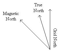
When working with a map and compass there are usually three different norths to be considered: True North, Grid North and Magnetic North. There is now a fourth: Google Maps North.

True North
Each day the Earth rotates about its axis once. The ends of the axes are the True North and South poles. True North on a map is the direction of a line of longitude which converges on the North Pole.
Grid North
The grid lines on Ordnance Survey maps divide the UK into one kilometre squares, east of an imaginary zero point in the Atlantic Ocean, west of Cornwall. The grid lines point to a Grid North, varying slightly from True North. This variation is smallest along the central meridian (vertical line) of the map, and greatest at the map edges. The difference between grid north and true north is very small and for most navigation purposes can almost always be ignored.
Magnetic North
A compass needle points to the magnetic north pole. The magnetic north pole is currently located in the Baffin Island region of Canada, and from the UK, is west of true north. The horizontal angular difference between True North and Magnetic North is called MAGNETIC VARIATION or DECLINATION.
Message to World Magnetic Model (WMM) Users NOAA/NCEI – March 21, 2018
The WMM Gridded Variation (GV) error has recently exceeded the performance specification in the Arctic region. Other geographic areas and other model parameters are not affected. The increased GV error may adversely affect compass navigation in those areas. This performance degradation is caused by fast changing core flows in the North polar region of the Earth’s outer core.
Google Maps North
Google Maps use a variant of the Mercator projection for its map images. The Mercator map was designed as an aid to navigators since straight lines on the Mercator projection are loxodromes or rhumb lines - representing lines of constant compass bearing - perfect for 'true' direction.
True North on Google Maps is not shown, but for a normal Mercator projection, grid north and true north will coincide and it will follow any vertical line (or meridian) to the top of the map.

The Three Norths
True North
Each day the Earth rotates about its axis once. The ends of the axes are the True North and South poles. True North on a map is the direction of a line of longitude which converges on the North Pole.
Grid North
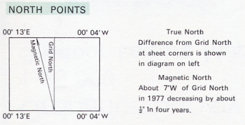
The grid lines on Ordnance Survey maps divide the UK into one kilometre squares, east of an imaginary zero point in the Atlantic Ocean, west of Cornwall. The grid lines point to a Grid North, varying slightly from True North. This variation is smallest along the central meridian (vertical line) of the map, and greatest at the map edges. The difference between grid north and true north is very small and for most navigation purposes can almost always be ignored.
Magnetic North
A compass needle points to the magnetic north pole. The magnetic north pole is currently located in the Baffin Island region of Canada, and from the UK, is west of true north. The horizontal angular difference between True North and Magnetic North is called MAGNETIC VARIATION or DECLINATION.

Ordnance Survey map showing Grid North, Magnetic North and True North variations for Purbeck UK, 1977
Message to World Magnetic Model (WMM) Users NOAA/NCEI – March 21, 2018
The WMM Gridded Variation (GV) error has recently exceeded the performance specification in the Arctic region. Other geographic areas and other model parameters are not affected. The increased GV error may adversely affect compass navigation in those areas. This performance degradation is caused by fast changing core flows in the North polar region of the Earth’s outer core.
Google Maps North
Google Maps use a variant of the Mercator projection for its map images. The Mercator map was designed as an aid to navigators since straight lines on the Mercator projection are loxodromes or rhumb lines - representing lines of constant compass bearing - perfect for 'true' direction.
True North on Google Maps is not shown, but for a normal Mercator projection, grid north and true north will coincide and it will follow any vertical line (or meridian) to the top of the map.
Copyright © 2009 - 2026 All Rights Reserved
Barcelona Field Studies Centre S.L.
Barcelona Field Studies Centre S.L.